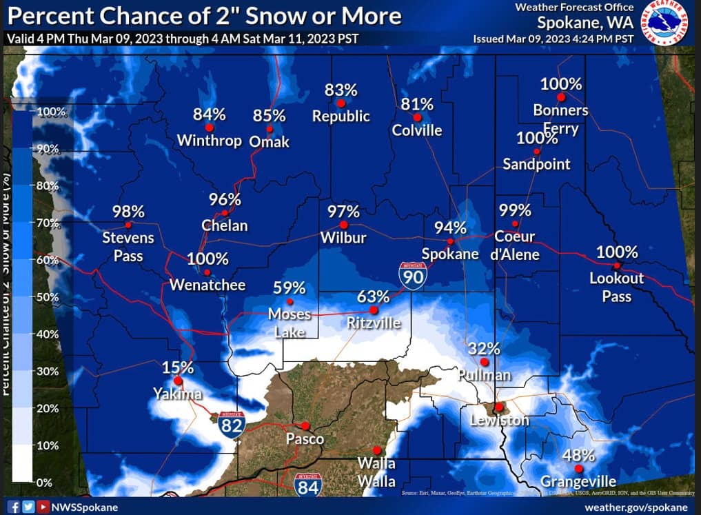
SPOKANE, WA – A widespread winter snow event is expected to impact much of the Inland Northwest beginning late tonight and continuing through most of Friday. Snow is expected to impact the morning commute over much of the region. Steady snow will transition to snow or graupel showers by the afternoon. The National Weather Service says some of these snow and graupel showers may bring bursts of heavy snow with reduced visibility and roads quickly becoming covered with slushy snow.
|
| KEY POINTS |
- Widespread snow late Thursday Night through Friday Morning. The heaviest snow will impact the Friday AM Commute
- Bursts of heavy snow or graupel with showers in the afternoon and evening on Friday.
|
| CHANGES FROM THE PREVIOUS BRIEFING |
Increased Snow Amounts
Winter Storm Warning issued for Waterville Plateau
Numerous Winter Weather Advisories issued
Areas of blowing and drifting snow are expected on the Waterville Plateau and Wilbur area |
| WEATHER RISK OUTLOOK |
| Risk levels incorporate potential impacts from weather hazards and the likelihood of occurrence. |
| Tonight |
4AM-Noon Friday |
Noon – 6 PM Friday |
Friday Night |
Saturday |
| Increasing Snow mainly after midnight |
Moderate to heavy snow |
Isolated bursts of heavy
snow with showers
Breezy |
Snow Idaho Panhandle |
|
| Risk Levels |
Little to None |
Minor |
Moderate |
Major |
Extreme |
|
| DETAILS |
| WHAT |
WHEN |
WHERE |
IMPACTS |
- Snow
- Confidence: High
|
late Thursday night-Friday |
Central and Eastern WA into North Idaho |
Snow amounts have increased with this system. Areas along and north of I-90 have a 70-95% chance of amounts over 2″. The Highway 2 corridor from Waterville through the West Plains, and the Idaho Panhandle has a 60-80% chance of amounts of 4″ or more. Snow will likely accumulate overnight and into the morning. In addition, areas of blowing snow are expected on the Waterville Plateau as well as the Wilbur area. By late morning and into the afternoon, road temperatures will be warming with snow likely melting on many of the area roadways. Dropping temperatures again Friday Night may result in a refreeze on some roads with additional snow. Confidence in the snow is high for most of the region, but moderate confidence in snow amounts. |
- Heavy Snow/Graupel Showers
- Confidence: Moderate
|
Friday afternoon-Friday evening |
Extreme Eastern WA into Idaho Panhandle |
Snow and graupel showers Friday afternoon and evening will bring the potential for bursts of heavy snow with visibility down to 1/2 mile or less. Roads may quickly become snow-covered with a layer of slushy snow or graupel resulting in slick road conditions. |
|
| FOR MORE INFORMATION |
| For the latest forecast updates, visit weather.gov/spokane. |


