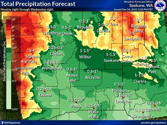
SPOKANE, WA – The National Weather Service says a moderate atmospheric river event will impact the Inland Northwest over the next couple of days with moderate to heavy rain over the Cascade crest, northeast Washington, and the Northern Panhandle. Rain on melting low-elevation snow will increase concerns for small stream and creek flooding, and flooding of low-lying areas, especially in those areas with poor drainage. Cooler temperatures and lower snow levels for the latter half of the week will result in a return of winter travel conditions.
| KEY POINTS |
- Snow levels with increasing rain over the Cascades, northeast Washington and the Northern Panhandle tonight through Wednesday.
- Warmer temperatures to melt low elevation snow, especially over the eastern half of eastern Washington and in the Idaho Panhandle.
- Rain and melting snow will result in rises on rivers, small streams, and creeks, and flooding of low lying areas possible through Wednesday night.
- Winter travel over mountain passes possible Thursday and a return of low land snow and moderate mountain snow possible for the weekend.
- Breezy conditions possible over Alpowa Summit and on the Palouse on Thursday.
|
| CHANGES FROM PREVIOUS BRIEFING |
Decreased rainfall accumulations from Palouse region into Central Panhandle Mountains south of I-90.
Removed the Flood Watch for Whitman, Benewah, and Latah counties |
| WEATHER RISK OUTLOOK |
| Risk levels incorporate potential impacts from weather hazards and likelihood of occurrence. |
|
Tue 12/5 |
Wed 12/6 |
Thu 12/7 |
Fri 12/8 |
Sat 12/9 |
- Heavy Rain
- Small Stream Flooding
|
Rain with Low Elevation Snow Melt |
Rain with Low Elevation Snow Melt |
|
|
|
| Snow |
|
|
Mountain Snow
Impacts at Mtn Passes |
|
Return of Low Elevation Snowfall |
| Risk Levels |
Little to None |
Minor |
Moderate |
Major |
Extreme |
|
| DETAILS |
| FOR MORE INFORMATION |
| For the latest forecast updates, visit weather.gov/spokane. |