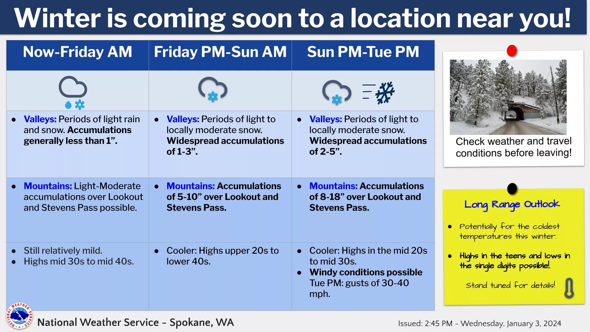
SPOKANE, WA – The National Weather Service says a change in the weather is forthcoming. The weather pattern will become more active with rounds of mountain snow and valley rain and/or snow late this week into at least mid-next week. Temperatures will become colder beginning Sunday and it will also become breezy on Saturday and Tuesday.
“Between now & next week we expect 3 systems to impact the Inland NW. The mildest occurs tonight to early Friday. More widespread snow expected this weekend. Possible coolest & most significant snow producer next week, possibly accompanied by strong winds Tuesday,” NWS says.
|
| KEY POINTS |
- Light mountain snow today (Wednesday) through Friday afternoon before more substantial mountain snow begins Friday evening.
- Valley and lowland temperatures will hover around freezing making snow accumulation difficult through Friday afternoon.
- Friday night through Sunday morning has the best chance of seeing valley snow accumulation.
- Temperatures become colder Sunday onward.
- Moderate to high accumulating mountain snow will continue Sunday evening into at least mid next week.
- Locally breezy conditions Saturday. Stronger winds next Tuesday.
|
| WEATHER RISK OUTLOOK |
| Risk levels incorporate potential impacts from weather hazards and likelihood of occurrence. |
| Wed 1/3 |
Thu 1/4 |
Fri 1/5 |
Sat 1/6 |
Sun 1/7 |
Mon 1/8 |
Tue 1/9 |
| Light Precipitation |
Cascade Snow |
Mountain Snow |
Widespread Snow |
Light Snow |
Light to moderate Snow |
Light Snow
Locally Windy |
| Risk Levels |
Little to None |
Minor |
Moderate |
Major |
Extreme |
|
| DETAILS |
| WHAT |
WHEN |
WHERE |
IMPACTS |
- Mountain Snow
- Confidence: High
|
Friday Evening through Sunday Afternoon |
|
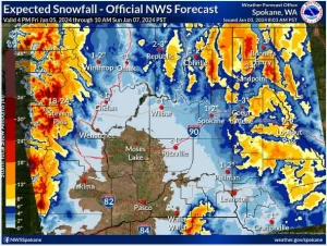
Stevens Pass: 90% chance of 6 inches or more; 70% chance of 12 inches or more; 40% chance of 18 inches or more
Sherman Pass: 55% chance of 4 inches or more; 25% chance of 6 inches or more; 10% chance of 8 inches or more
Lookout Pass: 70% chance of 4 inches or more; 50% chance of 6 inches or more; 20% chance of 12 inches or more |
- Valley Snow
- Confidence: Moderate
|
Friday Evening through Sunday Afternoon |
|
Spokane Airport: 85% chance of 1 inch or more; 60% chance of 2 inches or more; 30% chance of 4 inches or more; 10% chance of 6 inches or more
Sandpoint: 90% chance of 2 inches or more; 70% chance of 4 inches or more; 50% chance of 6 inches or more; 30% chance of 8 inches or more
Pullman: 85% chance of 1 inch or more; 60% chance of 2 inches or more; 25% chance of 4 inches or more
Moses Lake: 5% chance of 1 inch or more
Wenatchee: 5% chance of 1 inch or more
Omak: 10% chance of 1 inch or more
Colville: 75% chance of 1 inch or more; 50% chance of 2 inches or more; 15% chance of 4 inches or more |
- Mountain Snow
- Confidence: Moderate
|
Sunday Evening through Wednesday Afternoon |
|
Stevens Pass: 95% chance of 18 inches or more; 80% chance of 24 inches or more; 60% chance of 30 inches or more
Sherman Pass: 80% chance of 4 inches or more; 55% chance of 6 inches or more; 30% chance of 8 inches or more
Lookout Pass: 80% chance of 12 inches or more; 40% chance of 18 inches or more; 15% chance of 24 inches or more |
- Valley Snow
- Confidence: Low
|
Sunday Evening through Wednesday |
|
Spokane Airport: 90% chance of 1 inch or more; 40% chance of 4 inches or more; 25% chance of 6 inches or more; 15% chance of 8 inches or more
Sandpoint: 90% chance of 4 inches or more; 70% chance of 6 inches or more; 55% chance of 8 inches or more; 30% chance of 12 inches or more
Pullman: 95% chance of 1 inch or more; 40% chance of 4 inches or more; 25% chance of 6 inches or more
Moses Lake: 30% chance of 1 inch or more; 5% chance of 4 inches or more
Wenatchee: 30% chance of 1 inch or more; 5% chance of 4 inches or more
Omak: 45% chance of 1 inch or more; 5% chance of 4 inches or more
Colville: 90% chance of 1 inch or more; 55% chance of 4 inches or more; 30% chance of 6 inches or more |
|
| FOR MORE INFORMATION |
| For the latest forecast updates, visit weather.gov/spokane. |