

KAMIAH, ID—The days are getting shorter, and the nights are getting cooler in north-central Idaho, which usually means most hunting seasons are just around the corner. The Nez Perce-Clearwater National Forests say some areas of Idaho’s backcountry are already recording overnight temperatures at or near freezing. According to local forecasters, these areas will likely see the upper 90s, if not triple digits, by this weekend.
This creates a recipe for more active fire behavior and movement in some of the larger backcountry fires and higher elevations. Most grasses and shrubs begin to become available to burn where they may not have been prior to a frost, and the daily temperature fluctuations create more potential for wind events with extreme heating and cooling in the river canyons.
“This is the time of year when some of our active backcountry fires can stand up and make significant wind-driven runs,” says Josh Bransford, Fire Staff Officer for the Nez Perce-Clearwater National Forests. “Even though our temps have been slightly cooler than average for this time of year, the vegetation is still dry, and more of it will become available as we continue into a Fall weather pattern of cool nights and hot days.”
From the Nez Perce-Clearwater National Forests:
There are currently no fire restrictions in the Grangeville Dispatch Area, but fire managers from all represented agencies ask the public to remain vigilant and cautious when utilizing campfires for any purpose right now.
The potential for accidental human-caused fires greatly increases with hunting seasons opening, based simply on the fact that there are more people in remote areas of the forest during this Fall transition period. Cool nights are made more tolerable by building warming and cooking fires, but if not properly extinguished these seemingly innocent campfires can create wildfires with just a little wind.
Current Active Fires on the Nez Perce-Clearwater NF as of reporting time:
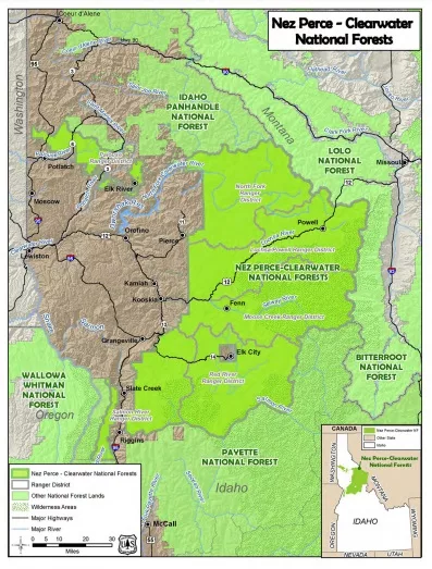
Salmon River Ranger District
Ace Butte Fire is a lightning-caused wildfire that was detected on July 24, 2024, and is located 22 ½ miles northeast of Riggins, ID. The fire is approximately 200 acres. Fire activity increased yesterday with the passage of a mostly dry cold front. Smoke and flames may be visible during the day. An area closure may be implemented if there is a significant increase in fire behavior this weekend.
Anchor Fire is a lightning-caused wildfire detected on July 28, 2024, and is located approximately three miles north of the Ace Butte Fire, and about 23 ½ miles northeast of Riggins, ID. The fire is approximately 400 acres. Fire activity increased yesterday with the passage of a mostly dry cold front. An area closure may be implemented if there is a significant increase in fire behavior this weekend.
Red River Ranger District
Cracker Jack Complex is composed of four different lightning-caused wildfires burning in the Gospel-Hump Wilderness: The Square Lake Fire, Whistling Pig Fire, Fish Fire, and Fish 2 Fire. Together, the fires are approximately 1345 acres. All four fires are located within half a mile of each other: two and a half miles east of Concord, ID, less than a quarter mile east of Square Lake, and less than a quarter mile west of Fish Lake. Fire activity increased yesterday with the passage of a mostly dry cold front.
Official trail Closures remain in place for the following:
· NFST #204 from the junction of FS Road #233 and NFST #204 South along FS Trail #204 to its junction with FS Trail #215 (10.9 Miles)
· NFST #230 from the junction or FS Road #233 and FS Trail #230 Northeasterly along FS Trail #230 to its junction with FS Trail #204 (5.8 Miles).
Moose Creek Ranger District
Wye Fire is a lightning-caused wildfire detected on July 25, 2024, and is located approximately four and a half miles northwest of Freeman Peak and seven miles northeast of the Moose Creek Airstrip. The fire is approximately 7,341 acres and continues to burn primarily in a 2015 fire scar.
*Multiple trail closures are expected in the vicinity of the Wye fire area with predicted weather and increased fire behavior this coming weekend. Please visit https://inciweb.wildfire.gov/incident-information/idncf-wye-fire for official closure updates.
Halfway is a lightning-caused wildfire detected on August 25, 2024, and is located approximately 5 miles West of Moose Creek Ranger Station and Airstrip. Fire is approximately five acres in size and has potential to impact Shissler Peak Lookout. Fire managers are assessing structure protection needs at Shissler Peak Lookout at this time.
Roll Tide Fire is a lightning-caused wildfire that was detected on July 28, 2024, and is located 22 miles southeast of Lowell, ID and 14 miles southwest of the Moose Creek Airstrip. The fire is approximately five acres.
Otter Fire is a lightning-caused wildfire detected on July 29, 2024, and is located approximately one mile north of the Roll Tide Fire, 22 1/2 miles southeast of Lowell, ID and 13 miles southwest of the Moose Creek Airstrip. The fire is approximately five acres.
Crimson Fire is a lightning-caused wildfire detected on August 8, 2024, and is located about four and a half miles south of the Moose Creek Airstrip and about nine and a half miles northwest of Gardiner Peak Lookout. The fire is now approximately 73 acres.
Doe Fire is a lightning-caused wildfire detected on August 17, 2024, and is located three miles east of Highline Ridge and five and a half miles northeast of Indian Peak. The fire is approximately half of an acre in size.
Monument Fire is a lightning-caused wildfire detected on August 19, 2024, and is located less than two and a half miles east of Freeman Peak and four and a half miles west of Wahoo Peak. The fire is now approximately 59 acres.
Moe Peak Fire is a lightning-caused wildfire that was detected on August 20, 2024, and is located one mile east of Moe Peak and three and a quarter miles south of Cove Peak. The fire is approximately a quarter of an acre.
Goat Creek Fire is a lightning-caused wildfire detected on August 21, 2024, and is located two miles southeast of Wylie’s Peak and two miles northeast of Boxcar Mountain. The fire is approximately one-tenth of an acre.
Surprise Fire is a lightning-caused wildfire detected on August 22, 2024, and is located three and one-half miles northeast of Hunter Peak and 15 miles northwest of Darby, MT in the Selway-Bitterroot Wilderness. The fire is approximately 40 acres.
Hunter Peak Fire is a lightning-caused wildfire detected on August 23, 2024, and is located less than one mile north of Hunter Peak and three miles east of Long Ridge. The fire is approximately one-tenth of an acre.
Archer Mountain Fire is a lightning-caused wildfire detected on August 23, 2024, and is located less than one-mile northeast of Archer Mountain and three miles east of Boxcar Mountain. The fire is approximately one-tenth of an acre.
Pinchot Point Fire is a lightning-caused wildfire detected on August 23, 2024, and is located eight miles west of the Moose Creek Airstrip and six and a half miles south of Blacktail Butte. The fire is approximately one-tenth of an acre.
Lochsa Ranger District
Bowl Creek Fire is a lightning-caused wildfire detected on July 26, 2024, and is located four and a half miles southeast of Rocky Ridge and seven miles northwest of Highway 12. The fire is less than 1/10th of an acre, and no visible smoke has still not been seen since the last week of July.
*This will be the last report on this fire unless significant activity occurs.
Powell Ranger District
Boulder Creek Fire is a lightning-caused wildfire detected on July 24, 2024, and is located ten miles north of the Powell Ranger Station and 12 miles west of Lolo Hot Springs. The fire is approximately 25 acres. Minimal fire activity has been observed.
Grave Butte Fire is a lightning-caused wildfire detected on July 29, 2024, and is located ten miles west of Jerry Johnson Campground and about half a mile from National Forest Service Road #107 (Saddle Camp Road). After a cold frontal passage yesterday, the Grave Butte Fire is still approximately 10 acres, but updated mapping is pending. The fire is burning in extremely inaccessible terrain.
While there are no official closures at this time, fire management urges the public to please avoid NFSR #107, due to the increased fire resource traffic going in and out of the area. This is for public and firefighter safety.