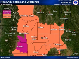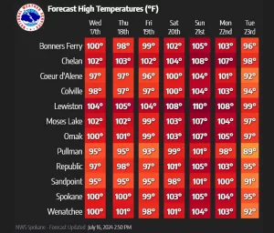

LEWISTON, ID—The National Weather Service in Spokane says temperatures 10-20 degrees above normal are expected in the Inland Northwest over the next seven days, with Moderate (orange) to Major (red) Heat Risk. Many areas are forecast to see highs between 100 and 110 degrees for the weekend.
The hot temperatures will increase the potential for heat-related illnesses for everyone, especially those without effective cooling or adequate hydration and those who work outside.
The weather will change slightly tomorrow, but not for the better. Meteorologists are predicting dry lightning in many areas and breezy conditions, which will increase the chances of more wildfires.
“Wednesday brings scattered thunderstorms with little to no precipitation. The best chances will be near the Cascades through the Waterville Plateau to the Okanogan Highlands, while more isolated t-storms are possible over the rest of eastern WA and north ID. Otherwise, dry conditions will periodically mix with breezy conditions, especially over central WA. Smoke will continue to impact air quality near wildfires, especially near the Cascades,” NWS says.
- Fire Concerns: Cascades and North Central Washington: There is a 20-30% chance of thunderstorms Wednesday afternoon through evening. Abundant lightning is expected. Hot, dry, unstable conditions across the Central Basin. A 10-20% chance of isolated thunderstorms with gusty outflow winds is possible.
- Moderate to Major Heat Risk: It will continue through early next week. High temperatures will be in the 90s to 108 degrees, and low temperatures will be in the upper 50s to low 70s.
- Smoke: Fires in the Cascades and southwest of Lewiston have been active and producing smoke. Other fires across the region are contributing to the smoke output. Smoke has impacted air quality at times within the Lake Chelan Basin and Methow Valley.
- UPDATED forecasts at: https://www.weather.gov/spokane.